|
|
HANDBOOKS PREPARED UNDER THE DIRECTION OF THE
HISTORICAL SECTION OF THE FOREIGN OFFICE.—Nos. 140. GALAPAGOS
|
|
Editorial Note.
——— In the spring of 1917 the Foreign Office, in connection with the preparation which they were making for the work of the Peace Conference, established a special section whose duty it should be to provide the British Delegates to the Peace Conference with information in the most convenient form— geographical, economic, historical, social, religious and political—respecting the different countries, districts, islands, &c., with which they might have to deal. In addition, volumes were prepared on certain general subjects, mostly of an historical nature, concerning which it appeared that a special stlady would be useful. The historical information was compiled by trained writers on historical subjects, who (in most cases) gave their services without any remuneration. For the geographical sections valuable assistance was given by the Intelligence Division (Naval Staff) of the Admiralty and for the economic sections, by the War Trade Intelligence Department, which had been established by the Foreign Office. Of the maps accompanying the series, some were prepared by the above-mentioned department of the Admiralty, but the bulk of them were the work of the Geographical Section of the General Staff (Military Intelligence Division) of the War Office. Now that the Conference has nearly completed its task, the Foreign Office, in response to numerous enquiries and reguests, has decided to issue the books for public use, believing that they will be useful to students of history, economics and foreign affairs, to publicists generally and to business men and travellers. It is hardly necessary to say that some of the subjects dealt with in the series have not in fact come under discussion at the Peace Conference; but, as the books treating of them contain valuable information, it has been thought advisable to include them. |
|
It must be understood that, although the series of volumes was prepared under the authority, and is now issued with the sanction, of the Foreign Office, that Office is not to he regarded as guaranteeing the accuraey of every statement which they contain or as itlentifying itseif with all the opinions expressed in the several volumes; the books were not prepared in the Foreign Office itself, but are in the nature of information provided for the Foreign Office and the British Delegation. The books are now published, with a few exceptions, substantially as they were issued for the use of the Delegates. No attempt has been made to bring them up to date, for, in the first place, such a process would have entailed a great loss of time and a prohibitive expense; and, in the second, the political and other conditions of a great part of Europe and of the Nearer and Middle East are still unsettled and in such a state of flux that any attempt to describe them would have been incorrect or misleading. The books are therefore to be taken as describing, in genera1, ante-bellum conditions, though in a few cases, where it seemed specially desirable, the aceount has been brought down to a later date. G. W. PROTHERO,
General Editor and formerly Director of the Historical Section. January 1920. |
GALAPAGOS ISLANDSTABLE OF CONTENTS
| |||||||||||||||||||||||||||||||||||||||||||||||||||||||||||||||||||||||||||||||||||||||||||||||||||||||||||||||||||||||||||||||||||||||
| |||||||||||||||||||||||||||||||||||||||||||||||||||||||||||||||||||||||||||||||||||||||||||||||||||||||||||||||||||||||||||||||||||||||||||||||||||||||||||||||||||||||||||||||
|
I. GEOGRAPHY PHYSICAL AND POLITICAL(1) Position and Extent
The Galápagos Islands or Colón Archipelago, belonging to the Republic of Ecuador, are a group of fifteen large and about forty smaller islands lying in the Pacific Ocean, 580 miles west of the coast of South America. The limits of the group are 0° 38' north to 1° 27' south latitude and 89° 16' 30" to 91° 40' 45" west longitude, with the exception of the two isolated islets of Wenman and Culpepper, which lie north-north-east of Albemarle Island, 77 and 97 miles distant respectively. The total land area is about 2,870 square miles. The largest islands are Albemarle or Isabela, 100 miles in length and 28 miles in extreme breadth, with an area of 1,650 square miles; Narborough or Fernandina, 250 square miles; Indefatigable or Santa Cruz, 390 square miles; James or San Salvador, 220 square miles; Chatham or San Cristóbal, 174 square miles; and Charles (King Charles) or Santa Maria (also called Floreana). The group was known as the Galápagos (Spanish, galápago = tortoise) before the time of the buccaneers, and, despite a decree of the Ecuadorean Government in 1892 renaming it the Colón Archipelago, so remains. The alternative Spanish names of the islands were given at various times. (See Appendix II, p. 25.) (2) SURFACE, COASTS, AND WATER-SUPPLY
Surface
The islands consist of little more than a series of volcanic peaks, some isolated, such as the islands of Abingdon or Pinta, Bindloe or Marchena, and Hood or Espanola, and others joined together by lava-flows to form larger islands. On Albemarle and Chatham |
islands there are several volcanic peaks on a continuous ridge, and the lava-flows have spread wide enough to form a good deal of low-lying land. On the other hand, two of the larger islands, namely Indefatigable and Narborough, consist each of a single volcanic peak. Altogether there are about 2,000 craters in the group, but only a few of these are prominent. The highest elevations are on Albemarle Island, 4,700 ft.; Narborough Island, 3,720 ft.; Chatham Island, 2,490 ft.; indefatigable 2,296 ft.; and Charles Island, 1,780 ft. Albemarle and James Islands alone have active volcanoes at present. There is little low-lying land, but the slopes on the larger islands are gentle until the interior is reached. Coasts
The coasts are, for the most part, steep and rocky and fringed with sunken rocks, and off many points there are reefs. The channels between the islands, though not adequately surveyed, seem to be deep and free from dangers. Tagus Cove in Albemarle Island is the only landlocked harbour; its shores are steep and inaccessible. The other anchorages are open bays, but, owing to the continuous fine weather, are safer than they appear on the chart. Most of them have, however, a northerly exposure, and so are open to the heavy rollers that come from the north during the rainy season. The chief anchorages 1 are Wreck Bay on Chatham Island, Post Office Bay on Charles Island, and Conway Bay on Indefatigable Island, but there are many others, and, in the absence of swell, landing is possible in most places. Water-Supply
The water-supply is poor and uncertain. Springs and streams are scarce; some islands have none, and on others they occur only during the wet season. The few springs that occur near sea-level are all brackish. 1 See also infra, pp. 19-20. |
Chatham Island is best supplied with water, and has a stream emptying by a waterfall into Freshwater Bay. There are also perennial springs an Charles Island, James Island, Indefatigable Island, and Albemarle Island. (3) Climate
&; &; The climate is, on the whole, warm and dry, but not excessively hot for a place situated on the Equator. The mean monthly temperature varies from 70° F. (21° C.) to 81° F. (27° C.). February and March are the warmest months, but even then the noon temperature at sea-level is seldom over 85° F. (29.5° C.). July to September is the cool season. The moderate temperatures of the islands are largely due to the cold Humboldt current which washes their shores. &; &; The south-east trade wind blows regularly from May to December or January, but in other months is uncertain, and calms often occur with light day breezes. &; &; The lower parts of the islands are very dry, and get showers only during the period from January to June, or in some years from January to March. This is called the spring season. It is irregular in its occurrence an different islands, and may even miss a year altogether. At higher altitudes the rainy season is from July to November, and the dry season from December to June. In some years there is a deficiency of rain. (4) Sanitary Conditions
The islands seem to be healthy, but in view of the scanty population no reliable information is available. If life at lower altitudes proved to be trying and enervating, the interior altitudes would probably provide ideal hill stations, the mean temperatures being some 10° F. (5.5 C.) lower than on the sea-coast. (5) Population
The islands were uninhabited until the arrival of small numbers of settlers in 1831, followed by the |
foundation of a small Ecuadorean colony in 1832, and of an Ecuadorean penal settlement (which is said to exist no longer) in the following year. By the middle of last century the colony of 250 free settlers had virtually disappeared, largely owing to murders by the convicts. For many years the only inhabitants were occasional hunters of wild cattle, but recently colonization has begun again, and is now increasing in importance. In 1913 Chatham Island had a population of 675 Ecuadoreans, chiefly engaged in sugar-growing at the settlement of Progreso. Albemarle Island had 115 inhabitants at the settlement of Port Villamil in 1903. Later figures are not obtainable. Charles Island occasionally has a few cattle-hunters. The other islands are uninhabited. &; The only two settlements are Progreso on Chatham Island, three miles from Wreck Bay, and Port Villamil on the south of Albemarle Island. Both settlements consist merely of a few huts. There is no garrison. |
II. POLITICAL HISTORYChronological Summary
|
(1) Early History
The existence of these islands was first made known by Tomas de Berlanga, third Bishop of Castilla del Oro, in New Spain, who found them accidentally in March 1535, while voyaging from Panama to Peru. By right of prior discovery, and in accordance with the Papal Bull of 1493 as modified by the Treaty of Tordesillas (1494), they fell within the dominions of the Emperor Charles V in his character of King of Spain. This claim, though not specifically asserted, was not challenged till 1832, when the Republic of Ecuador took formal possession of the archipelago. When discovered, the islands were without human inhabitants. In a letter 1 written by the Bishop to the Emperor, he described the parched and rock-strewn volcanic soil, the huge tortoises, iguanas, seals, and sea-turtles, the fearless birds, a saline spring, cacti, and other peculiarities, which, even apart from the evidence of the latitude observed by him, identify them as the Galápagos or Tortoise Islands. In 1540 two ships were despatched from Guatemala to examine the islands, which had again been sighted and reported by a passing vessel; but bad weather prevented the explorers from landing. The second definite discovery was made in 1546. when Diego de Rivadeneira, fleeing northwards from Quilca in a small ship, to escape from Gonzalo Pizarro's insurgent forces, fell in with a group of thirteen islands unknown to his pilot, which, from their geographical position and from the description of the soil and fauna, were clearly identical with those discovered eleven years before. This occurrence was forthwith reported to the Spanish authorities in Guatemala, and by them to the Viceroy of New Spain. 2 1 Printed in the Coleccion de documentos ineditos relativos a .... América y Oceania. See Pacheco, tomo XLI, 1884, pp. 538-544. See also the Boletin de la Sociedad Geográfica de Madrid, XXXI, 1891, pp. 352-55. |
Francisco de Castellanos, Treasurer of Guatemala, appealed to Prince Philip (afterwards Philip II) for permission to explore and settle the islands, 3 but no powers seem to have been granted, and in 1585 the islands were again accidentally met with by one Alonso Niño. 4 They had, however, already found a place on some maps, of which the earliest appears to have been that of Ortelius (1570). They are mentioned in the "Obervations" of Sir Richard Hawkins (son of Sir John), as known in 1593, though he does not seem to have visited them. 5 They were regarded as barren, and also had the reputation of being enchanted. 6 There is mention of some Spanish castaways being rescued by a Spanish vessel in 1605, 7 from "an island" called de los Galápagos. (2) Buccaneering Period
In 1684 various parties of buccaneers and filibusters, mostly under British commanders, made use of the islands. William Dampier was one of these. 8 In 1684 and 1685 the ship Batchelor's Delight, commanded by John Cook, visited the islands; and Ambrose Cowley, who was her sailing master, made the first general survey of the islands. Cowley's Charts 9 and journa1, 10 the latter of which has been twice printed, 11 are preserved in the British Museum. 0n her second visit, the Batchelor's Delight spent three months at the islands, and some of the particulars of this visit were recorded by her surgeon, Lionel Wafer. 12 3 Boletin, loc. cit., p. 364. |
Abundance of tortoise and iguana meat, fish also, and some fresh water were found; and one of the islands formed a convenient base for careening the ships, storing flour and other necessaries, treating the sick and wounded, and concerting future plans without being spied upon by the Spaniards. A good many Portuguese, Flemish, and French adventurers took part in these and similar proceedings. On the other hand, Captain Woodes Rogers, a privateer, complained, in 1709, of a lack of wood and water.13 Nevertheless, he returned to the islands a second time. Other Englishrnen (Clipperton14 and Shelvocke15) were there in and about 1720, The islands were also occasionally visited by Spaniards, who gave them Spanish names and made rough charts. There is still some confusion amongst the names given at various times by Englishmen and Spaniards; and more recently by the Ecuadoreans, at the celebration of the four hundredth anniversary of the discovery of America by Columbus. (See Appendix II, p. 25.) (3) Whaling Period
After the buccaneers and their occupation had disappeared, the Galápagos Islands lapsed in to oblivion for several decades, and only began to serve the purposes of man again when the South Sea whaling enterprise came into vogue, In 1793-94 they were twice visited and examined by Captain Colnett in the Rattler, despatehed by a leading firm of whale-ship owners to extend the knowledge necessary for whaling in the South Seas. Colnett male a rough survey of the islands, and described their rocky shores, abundance of seals, convenient anchorages, and vicinity to favourite resorts of the right kind of 13 Rogers, Woodes, A Cruising Voyage, &c., pp. 205-211, 261-265. |
whales. 16 Another partial and inaccurate survey of the islands was made in 1793 by Lorenzo Vacaro, "master" of the Spanish frigate Santa Gertrudiz.17 Vancouver, in H.M.S. Discovery, sighted some of the islands in 1795, but did not come to anchor. In 1797, 1800, 1813, 1819, and 1825 there were violent volcanic outbreaks, which did not, however, prevent British and North American ships from frequenting the islands to obtain wood and water. The eruption of 1800 was witnessed by Amasa Delano, an American shipmaster,18 that of 1819 by Captain Fanning,19 iand that of 1825 by B. Morrell, junior.20 To this time belongs the story of the wild Irishman, Patrick Watkins, who for five years lived alone on Charles Island (Floreana), made money out of the visiting whalers, and escaped with it to Guayaquil. 21 In 1813, during the war between England and the United States, Captain Porter, of the United States frigate Essex, made the islands an American base, and compelled twelve English whale-ships to surrender. Porter witnessed and described an eruption of the volcanoes in Albemarie and Charles Islands.22 During the war between Spain and her colonies the islands were used by privateers that preyed on Spanish commerce. When, however, the independence of the colonies was established, a change was not immediately
16 Colnett, J., A Voyage to the South Atlantic, &c., pp. 47-61, 137-161. |
made in the political status of the Gallipagos, and they continued for a time to be terra nullius. (4) Annexation by Ecuador
During the next few years several distinguished persons visited the islands. These visitors included Captain Basil Hall, of II.M.S. Conway, who conducted pendulum experiments at Abingdon Island (1822); Captain Lord Byron, of H. M .S, Blonde (1825); and Captain Duperrey, of the French frigate Coquille. But the epoch-making event in the history of the archipelago was the discovery, probably by a Spaniard, of orchilla or dyers' moss (Roccella tinctoria) on some of the islands, especially Charles Island. On this circumstance becoming known the Republic of Ecuador decided to annex the group. A politico-commercial syndicate was formed, with a certain Don Jose Villamil for its president, and to this syndicate a concession or charter was granted. Villamil was a native of Louisiana, who had migrated to South America, and greatly distinguished himself in the war between Ecuador and Peru, from which he emered with the rank of General. He had been chiefly instrumental in bringing the islands and the orchilla enterprise to the notice of the Ministry, and, in return, was appointed Governor of the new colony, with ample powers for administering its internal affairs. A pre-liminary exploring party was despatehed from Guayaquil in October 1831, and small batches of settiers followed. On February 12, 1832, Colonel Ignacio Hernández, representing the Government of Ecuador, took formal possession of the Galápagos Group; and at Charles Island, thenceforward called Floreana after President Flores, the administration was handed over to Villamil and another representative, Señor Lorenzo Bark.23 23 Villaviceneio, M., Geografia d la Republica del Ecuador, pp. 475-481; and Vidal Gormaz, in the Boletin de la Sociedad Geográfica de Madrid, XXXI, p. 156. |
(5) Development of Resources
General Villamil, having persuaded a few younger men of good family in Guayaquil to join him, set vigorously to work to develop the resources of the islands. He imported cattle, horses, swine, asses, goats, cats, and fowls, some of which were distributed from Floreana to other islands. Household vegetables were cultivated, and small plantations of sugar-cane, coffee, and various sub-tropical fruits established. The products were sold in cornsiderable quantities to the whaling captains; and it was probally at their instance that the settlers took to killing off the tortoises ruthlessly for the sake of their oil. In the course of a few years, the giant tortoise became extinct at Floreana and an some of the other islands. Unfortunately the Governor did not reside at Floreana continuously; and the settlers, a heterogeneous medley of characters largely recruited from unsuitable classes and occupations, proved wanting in perseverance and industry. Meantime, the Ecuadorean Government found it convenient to rid themselves of political opponents and military delinquents by relegating them to Floreana, under a pretext of furnishing the original settlers with the needed labourers; and it was not long before these malcontents were supplemented by a number of common criminals, so that the island became by degrees a loosely administered convict settlenient. In 1835 H.M.S. Beagle, commanded by Captain Robert FitzRoy, with Charles Darwin on board as surgeon-naturalist, paid a prolonged visit to the islands. The journals of both these officers are full of interesting matter bearing on the physical features of the islands, and their natural products; but contain little history. There were about 200 persons domiciled at Charles Island when the Beagle was there, and a few others were met with collecting tortoise oil at James Island, One Englishman and one Ecuadorean were then at Chatham Island supplying frech provisions to |
whalers. 24 In 1838 Captain Aubert Du Petit-Thouars, of the French frigate La Vénus, visited several of the islands, and wrote a good account of them. 25 (6) Domestic Troubles and Decay
By that time Villamil's "colonists," including convicts, had been scattered over several islands, and in 1837 the General resigned nis Governorship. He Was succeeded by a Colonel José Williams, whose violent character provoked a revolt (1841), ending in his flight. In 1842 Villamil returned to adjust matters, but found few occupants and no established authority. In 1845, there were still abont forty persons in the islands, living a life of independence, but of penury and squalor; and by 1849 no more than twenty-five remained. In 1852 a band of convicts, led by a man named Briones, on hearing that the Flores Government had been overthrown by a revoiution, murdered General Mena (who represented at Villamil at Chatham Island) and piratically seized a whale-ship, in which they proceeeled to Guayaquil, only, however, to be arrested, tried, condemned to death, and shot by the rebel Government there. Depravity and insubordination seem to have prevaiied for some time after these events, and the population became gradually dispersed. In 1853 some few survivors of the conviet settlers still remained; but they were so completely left to their own resources that, by 1868, they had dwindled to less than a dozen individuals living in a state of semi-savagery. In 1875 the number of whale-ships visiting the group did not exceed fifteen in a year, whereas, in the 24 Fitzroy, R., Narrative of the Surveying Voyages of H.M.S. Adventure and Beagie . . . . &c., vol. II, pp, 485-505; and Darwin, C., Journal of Researches . . . . &c., vol. III, pp. 453-478. |
early part of the century, as many as fifty used to resort to lt annually. The whaling industry in those seas has since almost died out; and the profit that used to be made out of it by settlers in the Galápagos Islands has correspondingly fallen away. (7) Partial Revival
The sattle, originally imported by Villamil in 1832, were supplemented and partly redistributed by him in 1845; they multiplied greatly, so that their number at Floreana alone, in 1858, was estimated at 4,000, all more or less wild. There were many others at Chatham and Albemarle Islands; and asses, goats, and pigs on some of the rest, notably a fine breed of half-wild asses at Indefatigable, and of wild pigs at James Island. Ships of war of various nations continued to call at intervals; and scientific parties busied themselves in collecting information and specimens 1n the group. The reports of their proceedings afford some information about the social, political, and commercial conditions they found there. Among such visitors were H.M.S. Herald and Pandora in 1846,26 the Eugénie27 (Swedish) in 1852, H.M.S. Zealous in 1870, and Chameleon a year later. Professor Louis Agassiz was there in the U.S. ship Hassler on a scientific mission in 1872; Commander Cookson, of H.M.S. Petrel, submitted a full and instructive report to the Admiralty in 1875: and Dr. Theodor Wolf, who visited four of the Islands in that year, did the same for the Government of Ecuador.28 Dr. Habel, a naturalist, collected birds in the archipelago in 1868; and finally, Professor Alexander Agassiz examined it
26 Seemann, B. Narrative of the Voyage of H.M.S. Herald . . . . &c., chap. IV, 1853. |
during his visit in the U.S. steam-vessel Albatross in 1891." A company was formed in 1858 called the "Orchillera Company," to work the orchilla. Among its most active promoters were Sres. José Monroy and Manuel J. Cobos, who reserved to themselves the right to colonize Chatham Island. Orchilla was still fitfully exported in 1868, as well as small quantities of salted fish, some tortoise oil, and a few hides. But the company was dissolved in 1870, and its concession as regards orchilla was taken up by Sr. José de Valdizan, who then removed to Floreana and established a homestead and a food plantation for the requirements of his collectors. By 187830 Valdizan's enterprise was in a fair way to flourish; but in July of that year the proprietor was murdered by one of his labourers, and Floreana was again abandoned. In 1893 Sr. Antonio Gil went to Floreana and planted a new settlement there — the third since Vallamil's attempt — but it only survived until 1897, when the founder decided to abandon it in favour of Albemarle Island, now called Isabela. There he erected a village, called Santo Tomäs; and a population of some 200 persons, living in 60 or 70 huts, gathered round him to work the deposits of sulphur in the island. They are reported to have prospered fairly well, down to 1907 or 1908 at least; and the wild eatile at Isabela are understocd to he still Sr. Gil's property. The sulphur was shipped to Guayaquil from a cove named Puerto Chico, situated opposite Brattle Island.31 Sres, Cobos and Monroy, in the meanwhile, laid the foundation of their settleinent at Chatham Island with a roll of thirty-seven persons. Sugar-cane, maize, root crops, and tropical fruits were planted, and corrals established for dealing with the cattle. By 1879 Cobos
29 Agassiz, A., in the Boletin de la Sociedad Geognifica de Madrid, vol. XXIII, 1892. |
had decided to settle permanently, and in 1881 considerable plantings of cane were undertaken. Five years later a factory with steam power was erected. Coffee plants were subsequently introduced, and by 1889 the community numbered 287 persons. The offier charged with the civil administration of the islands was then Don Pedro Jaramillo, who was assisted by a secretary, an inspector of police, a schoolmaster, and a light-keeper. Their authority was supported by a military commandant, four non-commissioned officers and fifty men of the National Guard32; but Sr. Cobos, being the employer of all the rest of the population, was popularly regarded "King" of the Galápagos. By 1893 his establishment had increased to 334, and the settlement was deserving of its name, "Progreso." Water had been laid on at considerable cost, and a Decauville railway had been constructed. But on January 15, 1904, a revolt took place among the workers; Cobos himself and the Government Commissioner, Sr. Leonardo Reina, were assassinated; and the insurgents, to the number of 78, fled from the island in a vessel they seized, and reached the Colombian coast. The next Commissioner appointed was Sr. Juan Piño, who found 245 inhabitants when he took over the administration.33 Their number has fluctuated between that and a litt> over 300 down to the time when the European War began. 32 Diario oficial, Quito. October 21, 1889, No. 151.
33 Monograph at end of El Ecuador: Guia, comerciai, agricola e industrial, 1909. |
III.SOCIAL AND POLITICAL CONDITIONS(1) Religious
Bishop Tomtis de Berlanga has recorded that, when.he accidentally discovered some of the Galápagos Islands in 1535, he used the occasion to celebrate Mass an shore there.34 From that date the history of religious worship in the Archipelago is a complete blank until March 1832, when Dr. Eugenio Ortiz, who was the chaplain accompanyin.g the annexation party from Guayaquil, celebrated Mass "for the second time in 300 years," it is said, at a spot in the isle of Floreana they named El Asilo de la Paz.35
Since that time Floreana has been thrice colonized and thrice deserto& and it does not appear that the population settled there or at Chatham Island has ever provided itself with a chureh or a chaplain. At the smaller settlement, called Santo Tomäs, in Isabela (Albemarie) Island, a church was built36; but no particulars are available. Roman Catholicisin is nominally professed by the mass of settlers; but Ecuadorean law permits the practice of any form of worship not contrary to its institutions or moral principles, though several restrictions are, or were, in effect imposed. The islands, as a group, are included in the diocese of Guayaquil. (2) Political
The governrnent of the island colony since 1885 has consisted of an administrator, whe was expected to apply the common laws of Ecuador; the islands having
34 Pacheco, J., Coleccion de documentos ineditos . . . . XLI, Madrid, 1884. |
been constituted, in 1832, a dependency (subsequently proclaimed a territorial part and parcel) of the province named Guayas, of which Guayaquil is the capital. In 1889 the administrator's authority was supported by five officers and fifty men of the National Guard, and an Inspector of Police." In 1885 the National Congress passed an. Act to exempt the colonists from taxation of all kinds, relieved them entirely from military service, fixed the area to he granted to settlers for cultivation free of rent, and created the post of "Jefe Territorial" or Resident Commissioner. A residence for this officer, with the nucleus of an administrative building, was erected at Chatham Island in the following year; and a leading light for shipping was installed at Puerto Chico.38 By 1913 these buildings were a state of decay beyond the possibility of repair. There were no quarters for the police, who consisted of twelve constables and an inspector, so that they had to be billeted in various private lodgings, to the detriment of their efficiency and independence. No poloce cells were provided by the Government; but two had leen constructed of galvanised iron sheets, lent by the sugar factory for the purpose. The light-keeper's quarters were also in a ruinous condition; and the Commissioner's report for that year is devoted to lamentations that nothing was done for the colony by the Government of the Republic, and no regular or expeditious communications had been established, either with the mainland or with the other islands. A sum of $24,000, nevertheless, stood on the Estimates of 1912 for expenditure on Public Work in the group, officially named since 1892 "El Archipielago de Colón." The report (No. 24), which reads like an appeal ad misericordiam, is signed by Sr. Caesar Aray Santos as Commissioner, and addressed to the Provincial Governor of Guayas.
37 Diario oficial, Quito, October 21, 1889, No. 151. |
(3) Educational
Particulars of education in the Galápagos Islands are exceedingly few, because little or nothing has been done by the Republic or the Province to promote or assest such trifling efforts as have been made by the settlers and the factory at Progreso. The list of officers on the establishment of the Islands in 1889 included a schoolmaster; but the list of buildings contains no mention of a school. In the latest available Report of the Commissioner,39 printed as an Appendix to the Minister of Public Education's Annual Return for 1913, it is stated that a notable advance had been made, inasmuch as there then existed a mixed school, conducted at the Government's expense, at which 24 children, more or less, counting both sexes, attended daily "with real satisfaction to their parents." The school was situated, however, on land belonging to the factory at Progreso, and was hygienically defective. It also lacked a proper outfit. No other particulars of the school are supplied. The Report (which in other respeets is by no rneans an optimistic one) states, however, that the vicious element formerly so notorious among the settlers had almost disappeared that in 1913 the existing population was a peaceful and industrious community, engaged in cultivating the soll; and that their social and material improvement now seemed assured. No figures or statisties are quoted in the Report. 39 Informe Anual del Ministro de Indruccion Publica, Quito, 1913. |
IV. ECONOMIC CONDITIONS(A) MEANS OF COMMUNICATION(1) Tracks
There are no roads, properly speaking, in the islands, but there is a track in Chatham Island from Wreck Bay to Progreso — a distanee of 3 miles. Tracks have also been made in Charles Island. (2) Railways
There is a light railway, 7 kilometres in length, from Progreso to the quarries, used for bringing sugar-cane to the mills at Progreso. (3) Ports
There are no harbours, but there are various open bays where, owing to the continuous fine weather, anchorage is usually safe. Several of these might be transformed into good harbours by the construction of moles, but labour and most of the material necessary would have to be imported. Chatham Island offers several good anchorages, of which Wreck Bay is the most important, because it is the port of the sugar factory at Progreso. The bay is about three-quarters of a mile wide at the entrance and extends for about half a mile; there is secure anchorage in 6 fathoms. pier 150 yds. long extends in a north-westerly direction, and there is a storehouse at the head of the cove, where the track to Progreso begins. Fresh water has been brought in pipes to the end of the pier from a lake in the high part of the island. Stephens Bay, locally known as Porto Grande, is a larger anchorage with an excellent |
landing place. There are other anchorages at Terrapin Road and at Freshwater Bay; at, the latter place there is a good supply of fresh water, but the watering place cannot always be approached on account of the surf. This bay and Wreck Bay axe the only watering places for shipping in the islands that can be depended upon. Charles (Floreana) Island has one of the best anchorages in the archipelago, at Post Office Bay. The bay is of moderate depth and easy of access, but no fresh water is to be had. There is also good anchorage at Black Beach Bay. In Indefatigable Island there is anchorage at Conway Bay in from 5 to 7 fathoms, with good landing for boats; there are also anchorages at Baquedano Bay and Puerto Nuñez. Water is obtainable at the last. The best anchorage on James Island is in James Bay, where vessels can anchor in from 7 to 14 fathoms. In Albemarie Island there is anchorage off the settlernent at Port Villamil in 5 1/2 to 7 1.2 fathoms. There is, however, a heavy swell, and though a small mole has been constructed, landing is difficult, as access to it is obstructed by hidden stones near the surface of the water. Tagus Cove is a snug anchorage formed by an old crater, the width at the entrance being nearly half a mile. There are other anchorages at Iguana Cove, Webb Cove, Isabel Bay, and Bahia Cartago. There is a fair anchorage off Abingdon Island, and landing can be effected a mile and_ a half to the north-ward of the anchorage. In Hood Island there is an anchorage on the north-east side, at Gardner Bay. Free ports have been established in the islands, but it is provided that foreign merchandise transported from these ports to ports on the mainland shall be subject to customs duties, wharfage, &c., as if it had never entered the Galápagos Islands. Trade with Guayaquil is carried on from Wreck Bay by a sailing schooner which comes to the island nominally once a month. |
(4) Wireless Communications
In an article which appeared in La Prensa at Havana on February 8, 1918, it was stated that a wireless installation exisied on Charles Island; and in September of the same year it was announoed that the Marconi Company proposed, with the consent of the Government of Ecuador, to establish a wireless station on one of the islands. (B) INDUSTRY
(1) Labour
It is provided by law that three-quarters of the colonists must be Ecuadoreans, and the executive is prohibited from contracting with foreign nations or foreigners for the colonization of these islands. (2) Agriculture and Products
Though agriculture is the principal source of wealth in the islands, there are comparatively few people engaged rn it, and only a small proportion of the land suitable for the purpose has been cultivated or cleared. Charles Island, which was the first to be settled, is now practically abandoned, and the settlements are in ruins, but it offers more advantages for farming than most of the other islands, as it has been partially cleared, and some tracks have been made. The islands are fertile, producing fruit and vegetables, timber, and most sorts of grain except rice. Sugar-cane, oranges, and lemons ripen all the year round, and two crops of maize, coffee, and potatoes are obtained annually. Cotton is also found. A product which was formerly important was orchilla or dyers' moss. Before the discovery of aniline dyes, this formed the basis for the manufacture of certain colours, and its collection was a profitable commercial undertaking A number of cattle, goats, horses, and swine were |
landed an these islands by General Villamil, and have greatly increased. The number of cattle in Albemarle Island alone in 1911 was stated bo be about 40,000. Formerly the principal produet of the islands was the terrapin or land tortoise. These hege tortoises at one time swarmed over the islands; some speeimens were over 5 ft. long and weighed as mueh as 600 lb. The tortoises were easy to capture, and they supplied ships with fresh meat. Oil was also extracted from them. Cheaper substitutes derived from petroleum have taken the place of this oil, hut the number of the tortoises had already been vastly diminished. (3) Fisheries
The fishing grounds of the group have been famous for years. Cod are numerous in the vicinity, and clawless lobsters and oysters are found an the rocks surrounding the islands. There appears to be a considerable future for these fisheries. The sea is calm, tempests and fogs are almost unknown, the situation is near the markets of South America, and the good climate and fertility of the islands would assure the rapid development of fishing settlements, The large local deposits of salt could be utilized for an industry in salted fish. Seals were formerly very numerous in the waters of the archipelago. In 1914 a company engaged in the fishing industry in Southern Chile petitioned the Government of Ecuador for permission to fish for whales in the waters of the Galápagos Islands. (4) Minerals
The sugar factory at Progreso is stated to be worked by coal mined in the island, but this coal is said to be of no use for steam vessels. Lime is obtained from the rocks round Wreck Bay, in Chatham Island, and is exported to Guayaquil. There are lange deposits of salt. There are also a number of sulphur deposits, as might be expected in |
islands of volcanic formation; some investigators believe that these may prove to be a considerable source of wealth. In 1909 a sulphur mine was being worked on Albemarie Island. (5) Manufactures
A sugar factory, using steam power, was established in 188640 at Progreso, on Chatham Island. Most of the inhabitants are employed in the factory, and the annual output is said to be as much as 3,000,000 lb.41 The annual production of coffee on the Progreso plantation is about 300,000 lb., and of alcohol about 14,400 litres. The production of vinegar is another industry which employs a few people. (C) COMMERCE
Hides, sugar, rum, vegetables, and fruit are exported to Guayaquil. No figures are available. There is also an export of cattle. lt is stated that in 1914 the Chilean Ecuadorean Society contracted with Sr. Antonio Gil42 for 5,000 head of cattle, to be delivered at Port Villanül for shipment to Chile.
40 See above, p. 15. |
APPENDIXI
DISTANCES FROM FLOREANA (CHARLES ISLAND) 1
(Galápagos Islands).
1 From a memorandum by the (late) Hydrographer, Sir Frederic Evans, February 10, 1879. |
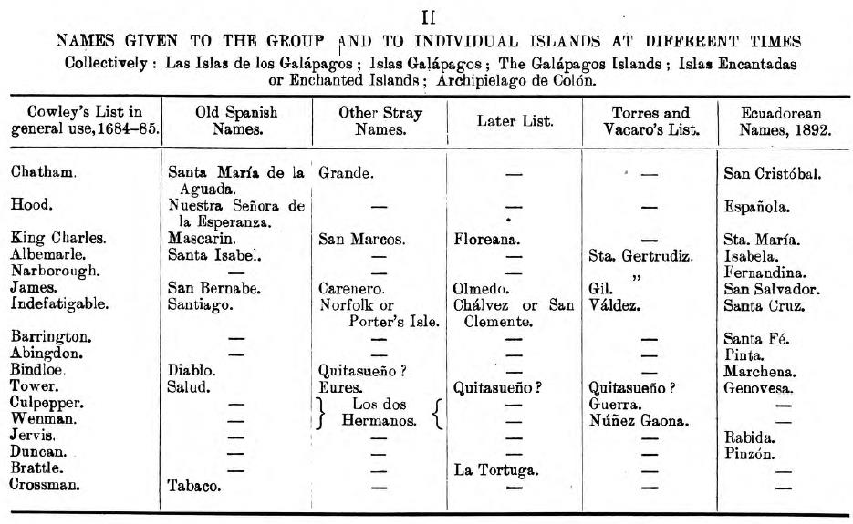
Names Given to the Group and to Individual Islands at Different Times.
|
AUTHORITIESHistorical
|
|
Economic
Maps
The Intelligence Division of the Naval Staff have issued a map of the Galápagos Islands, on the scale of 1:1,500,000, in connexion with this series. |
|
Source.
Great Britain.
This publication is available at the Hathi Trust.
Last updated by Tom Tyler, Denver, CO, USA, December 28, 2024.
|
|

